About us

Managing Director & Exploration Geologist
Over 25 years experience in geological studies and exploration projects worldwide for hydrocarbons, geothermal energy, mineral placer deposits and groundwater.
Formerly he held Sr. Geoscientist positions in Schlumberger (Italy), Fugro (United Kingdom & The Netherlands) and CGG (The Netherlands) and Sr. Geoscientist and management positions in Fugro (The Netherlands), responsible for team and project management and business development. He started his career as a geologist at Clyde Petroleum Exploration (Gulf Canada Resources) in The Netherlands in 1998. He holds an MSc degree from Utrecht University (The Netherlands). Member of EAGE, AAPG and IGA and member of board of stakeholders ETIP-DG, European Technology & Innovation Platform on Deep Geothermal – Mexico Geothermal Projects.

Structural Geologist
Professor in structural geology at the Middle East Technical University (Ankara, Turkey)
Over 25 years experience in geological studies and exploration projects worldwide for hydrocarbons, geothermal energy and minerals as well as in geotechnical projects.
He is Professor in structural geology at the Middle East Technical University (Ankara, Turkey) and visiting research fellow at Utrecht University (The Netherlands). Formerly he was consultant to Fugro and Ion Geophysical. He holds a PhD degree from Utrecht University and an MSc and BSc degree from Middle East Technical University.

Associate - Geophysical Advisor
owner Moser Geophysical Services
Dr Tijmen Jan Moser holds a Ph.D. from Utrecht University and has served as a geophysical consultant for numerous companies and institutes (Amoco, IFP, Karlsruhe University, Bergen University, Norsk Hydro, Geophysical Institute of Israel, Fugro-Jason, Horizon Energy Partners). In recent years he has been working as an independent geophysical consultant. His main interests include seismic imaging, asymptotic methods and diffraction imaging, a subject on which he has authored many influential papers.
What we do
Risk Reduction in Exploration for Natural Resources
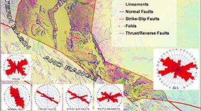
The strength of the application of multiple data sets (seismic, non-seismic and remote sensing) and multiple techniques is finding evidence for interpretations on more than one data set, allowing the presentation of evidence based interpretations. Over the past decade we have successfully applied and further improved the integrated approach described above in the region for several E&P companies in worldwide in passive, active and transform settings and margins addressing Provenance - source to sink reconstructions. All our studies are GIS based.
Natural Hydrogen and Helium Identification of source-reservoir-trap system deploying gravity-magnetic-magnetotelluric-seismic-geologic and remote sensing data. De-risking reservoir quality through provenance reconstruction.
Hydrocarbons Clastic reservoir Provenance Analysis, GIS-structural mapping on gravity, magnetic and remote sensing data, Seismic and well data interpretation, Gravity & Magnetic 2D/3D modeling to verify or improve existing seismic interpretations of intrusions, salt etc, Estimate depth to and inversion of the basement horizon, Denudation and erosion analysis (for basin modeling).
Geothermal Exploration permit study & reporting, GIS-geological mapping, interpretation and modelling of gravity, magnetic, MT, seismic, remote sensing and well data, structural and geological mapping of geothermal reservoirs, temperature anomalies and surface manifestations of geothermal systems. Assisting in application for exploration permits.
Mineral Field, and laboratory analysis on outcrop samples for the reconstruction of fault kinematics and basin development and detection of mineral orebodies, Spain. Application of thermochronology, gravity and magnetic data. GPR and EM sensor fieldwork and mapping of buried UXO in coastal area, The Netherlands.
Ground Water GIS- structural interpretation to map aquifers on Remote sensing, MT, gravity and seismic with well data.
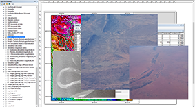
GIS & Remote Sensing GIS geodatabase construction, Remote Sensing (aerial photo, Spot, Landsat, Terra, SRTM etc) image analysis and (geological) interpretation.
Our Services
Exploring for Hydrocarbons, Natural Hydrogen, Helium, Geothermal, and Mineral deposits
Optimize your Bid and De-risk your Investments.
Gain Insight into the Provenance, Mineral composition and Depositional areas of clastic reservoir sediments to support your search for the best blocks on offer.
Provenance Analysis / Source to Sink
To reconstruct the paleo loci of deposition and quality of Reservoirs and Fluvial/Placer-deposits via integrated drainage analysis. Results allow more realistic 2D models and inversions that utilize potential field, well and seismic data.
Constrained Basement Inversion and -Structural Interpretation
To improve seismic interpretation and Time-Depth conversion via 2D modeling and inversion of gravity and magnetic data.
Potential Field data Structural Interpretation and 2D Modeling
To support provenance reconstructions and improve seismic interpretation of salt, intrusions and basement.
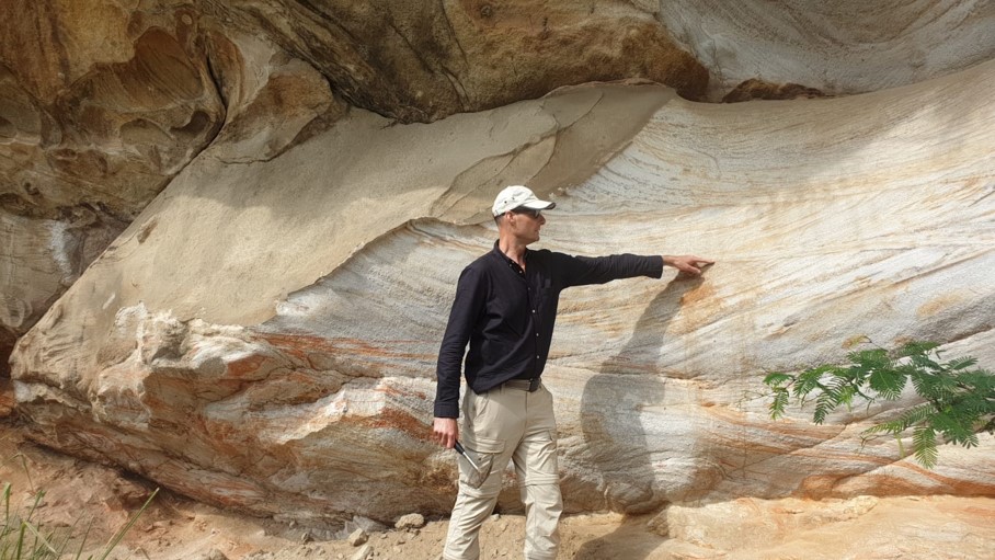
Fieldwork and Lab Analysis
To investigate the geology and provide ground-truthing for desktop study interpretations and modeling (eg rock sampling, mineralogy, Fission Track dating and structural mapping).
Morpho-Tectonic and
Denudation Analysis
To model erosion and uplift history of paleo drainage basins and support Provenance Analysis and basin modeling.
GIS & Remote Sensing
GIS geodatabase construction, Remote Sensing image analysis and (geological) interpretation.
Seismic Interpretation
Integrated interpretation of seismic and non-seismic data for optimized geological models.
Seismic re-processing, Imaging and Depth Migration
Re-processing of vintage 2D and 3D seismic data, seismic image improvement and depth migration through various in-house workflows and algorithms. For more information contact dr. T.J. Moser (Moser Geophysical Services).
Diffraction Imaging
Providing detailed fractures and faults from pre-stack and refraction seismic data. For more information contact dr. T.J. Moser (Moser Geophysical Services).
Static Structural Modelling
Construction of 3D structural – geological models which include interpretation and modelling results of seismic and non-seismic data. Ultimately, input for dynamic modelling.
Kinematic & Seismicity analysis
Detailed kinematic analyses on fractures and faults retrieved from various data sets: remote sensing, seismic and non-seismic. Seismicity risk analysis builds on the kinematic analysis to understand the risk of seismicity during drilling and production.
Structural Balancing & Restoration
Optimization, validation and quality control of interpretation and modelling results on both seismic and non-seismic data, supported by thermochronology data to date the timing of deformation, trapping, or mineralization events.
Experience Hydrocarbon Exploration
We have carried out multiple petroleum projects worldwide.
Europe
- FTG & Gravity integrated with 3D Coil Seismic & 2D Seismic interpretation of salt and inverted basement structural interpretation Nordkapp Basin region, offshore Norway.
- Gravity & Magnetic with well data interpretation & 2D modeling, Norwegian Basin, offshore Norway.
- FTG, Gravity & Magnetic structural interpretation & 2D modeling for shale gas exploration, on- & offshore Denmark.
- Gravity & Magnetic with 2D seismic &well data interpretation & 2D modeling, Voring Basin, offshore Norway.
- Block Evaluation studies, on- & offshore Netherlands.
- Core description of wells offshore Norway.
- Prospect & Play mapping, offshore Netherlands & UK: 2D and 3D seismic interpretation and well data analysis.
- GIS Atlas mapping, on- & offshore Netherlands.
Africa and Middle East
- FTG & MT with 2D seismic structural and stratigraphic interpretation, South Magadi Basin, onshore Kenya.
- FTG, Gravity & Magnetic with 2D seismic interpretation and 2D modeling of salt and inverted basement structural interpretation, supported by well data, Red Sea Basin, offshore Saudi Arabia and Egypt.
- FTG, Gravity & Magnetic structural interpretation and 2D modeling of inverted basement structural interpretation, Northern and Southern Magadi Basin, onshore Kenya.
- Gravity & Magnetic structural interpretation, onshore and offshore East and Southern Africa.
- FTG, Gravity & Magnetic structural interpretation and 2D modeling of inverted basement structural interpretation, Lake Nyanza Basin, onshore Kenya.
- Gravity & Magnetic structural interpretation and 2D modeling of inverted basement structural interpretation, Malagarasy Basin, onshore Tanzania.
- Gravity interpretation, Ovambo Basin, onshore Namibia.
- Gravity & Magnetic structural interpretation. Offshore Angola-Namibia.
- Drainage Analysis Black Sea Region.
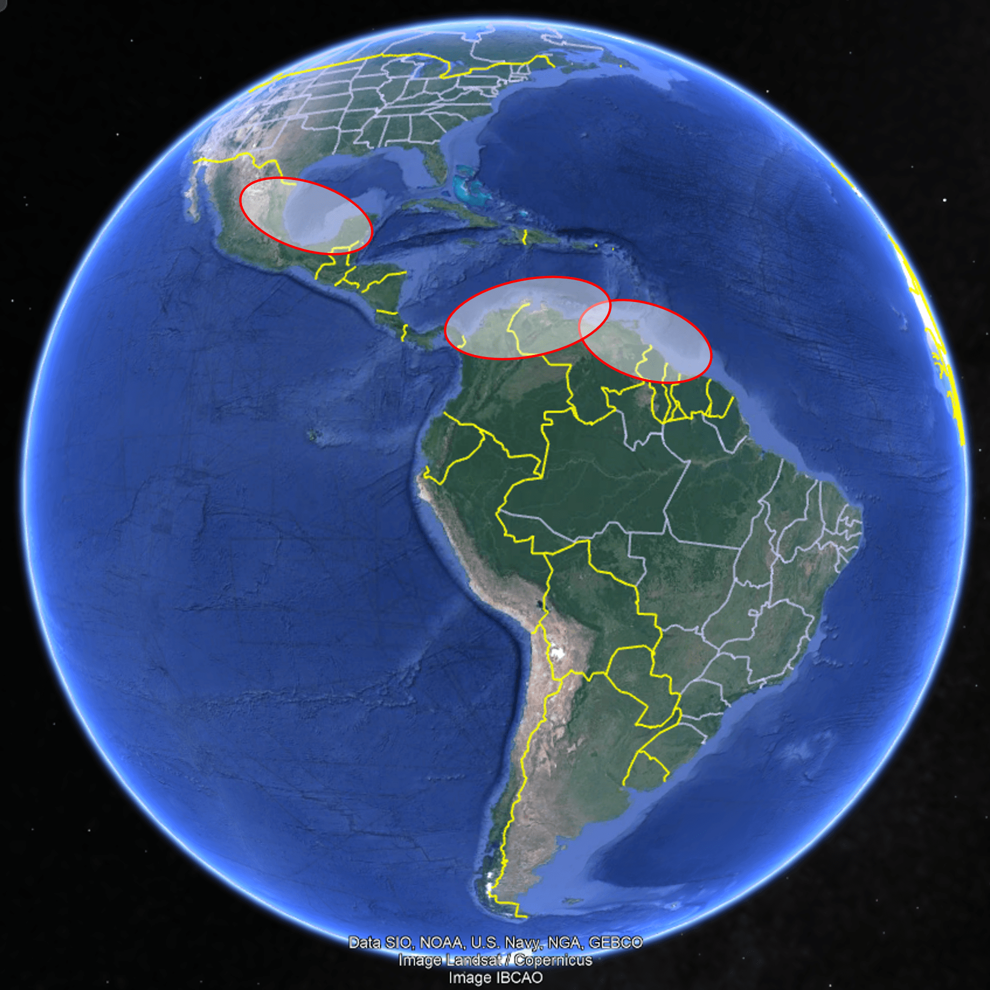
- Provenance Analysis for the West African margin, Ivory Coast-Namibia, on- & offshore sub-Saharan Africa: drainage analysis, morpho-tectonic interpretation, 2D seismic interpretation.
- Provenance reconstruction of circum-Turkey basins for Neogene clastic reservoirs.
Asia and Oceania
- Provenance Analysis Pilot study East Kalimantan.
- Gravity & Magnetic structural interpretation & 2D modeling, Northern Aceh Basin, offshore Sumatra, Indonesia.
- Sediment Mass Balance study for the basins of Sulawesi to PNG, Indonesia: 2D seismic interpretation and seismic stratigraphy, well data analysis and integration of Provenance analysis results.
- Provenance Analysis study for basins of Sulawesi to PNG, Indonesia: basin review, morpho-tectonic interpretation, drainage analysis, denudation & erosion analysis, paleo geology/geographic & drainage basins reconstructions.
- Organizing and conducting a Training course in Drainage Network Analysis, Malaysia.
- Provenance Analysis for the Arabian Sea, on- & offshore Pakistan: drainage analysis, morpho-tectonic interpretation.
- Provenance Analysis Pilot study North Island of New Zealand.
- Gravity & Magnetic structural interpretation, Pegasus Basin, offshore New Zealand.
America's
- Provenance reconstruction of Cretaceous-Tertiary clastic reservoirs in the South Brazil-Ururguay basins.
- Enhanced Provenance Reconstruction for Cretaceous clastic reservoirs in the Trujillo Basin, Peru.
- Provenance Reconstruction for Cretaceous to Neogene clastic reservoirs in the Trujillo Basin, Peru.
- Provenance reconstruction of Cretaceous-Tertiary clastic reservoirs in the Colombia-Venezuela-Trinidad basins.
- Provenance reconstruction of Cretaceous-Tertiary clastic reservoirs in the Guyana-Suriname basin.
- Provenance reconstruction of Tertiary clastic reservoirs in the Burgos, Tampico-Misantla, Veracruz and Sur-Este basins, Mexican Gulf of Mexico.
- Provenance Analysis Pilot study Western Mexican Gulf of Mexico.
- Gravity & Magnetic interpretation of salt and inverted basement structural interpretation, Mexican Gulf of Mexico region, offshore and onshore.
- Gravity & Magnetic interpretation and 3D modeling of salt and inverted basement structural interpretation, USA Gulf of Mexico Region, supported by well data, offshore and onshore.
- Gravity & Magnetic structural interpretation & 2D modeling, Sur Este Basin, offshore Mexico.
- Gravity & Magnetic structural interpretation, Parecis Basin, onshore Brazil.
- Gravity & Magnetic structural interpretation, NE coast basins. Offshore Brazil.
- Block Evaluation study Magallanes Basin, on- & offshore Chile: 3D seismic interpretation & seismic stratigraphy and well data analysis.
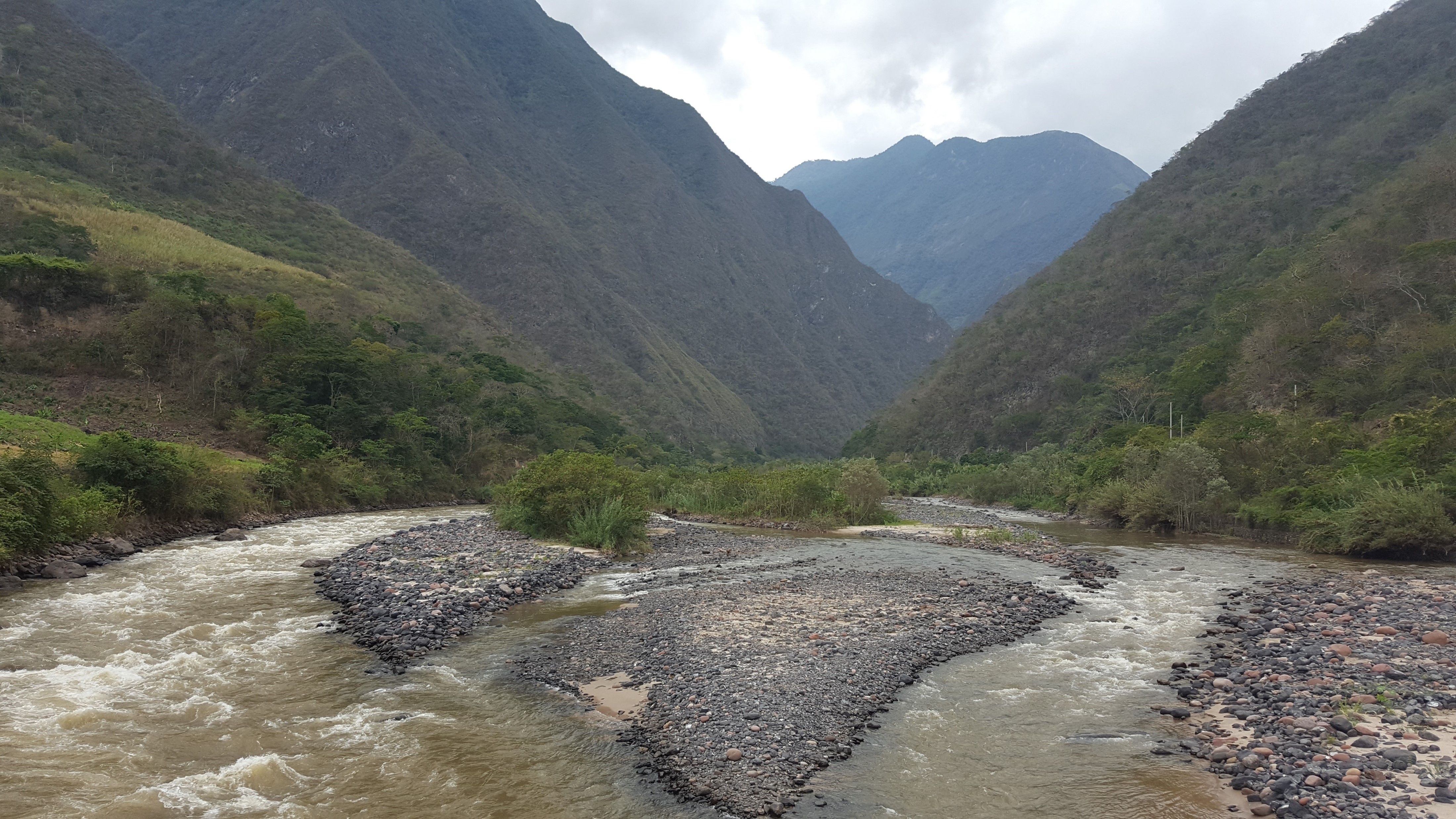
- Provenance Analysis for the Ucayali Basin, onshore Peru (PhD research): fieldwork, mineral separation & radiometric dating Apatite Fission Track Analysis, morpho-tectonic interpretation, remote sensing & GIS interpretation.
- Provenance reconstruction of Late Jurassic-Tertiary clastic reservoirs in the northern Peruvian and southern Ecuadorian margin and onshore basins.
Morphotectonic studies
-
South America:
- TMapping of structures at 1-arc second resolution, morphotectonic and kinematic analyses with structural balancing and restoration for provenance reconstruction studies. Turkey:
- The studies in Turkey cover large parts of subjects related to structural geology and tectonics. These include analysis, 3D characterization and evolution of sedimentary basins, active tectonics and morpho-tectonics for active fault mapping and regional kinematics, application of paleomagnetism and remote sensing techniques, as well as potential field data, reflection seismology like deep SPAN data interpretation and 3D modelling. Indonesia:
- The studies in Indonesia include interpretation of 2D and 3D seismic data, high resolution bathymetric imagery, and morphotectonic mapping, construction of crustal scale cross-sections and interpretation in terms of regional tectonic evolution of the on- and off-shore areas from Sumatra to Irian Jaya (west Papua) region. Circum-Gulf of Mexico:
- The studies in Circum-Gulf of Mexico includes interpretation of deep SPAN data, morpho-tectonic analysis of onshore Mexico and southern USA. Zagros/Iraq:
- Evaluation of petroleum potential of northern Iraq and Zagros fold belt using various data sets. Pakistan:
- Field mapping and structural analysis of Potwar Plateau and Salt Range. The study includes both classical field studies, paleomagnetism, structural analysis and fault kinematics, tectono-stratigraphy and cross-section balancing and palinspastic reconstructions. Colombia:
- Evaluation of petroleum potential of Cauca, Magdalena, Catatumbo, Maracaibo, Llanos, and Barinas basins using various data sets. Peru-Ecuador:
- Remote sensing and SRTM interpretation 1:50,000 scale.
Seismic Interpretation projects
-
US-Gulf of Mexico:
- Interpretation of Ion SPAN seismic data sets. Netherlands:
- Regional to block evaluation studies including Namurian (Mainly DEFAB blocks), Permian - Groningen and surrounding gas fields (P, F and K blocks), Triassic-Jurassic (Blocks around Dutch Central Graben), and Tertiary shallow (A, B and D blocks) gas fields.
- Onshore surface to Basement geothermal exploration studies supported by Gravity & Magnetic modeling and interpretation results. Indonesia:
- This includes interpretation of a large mainly 2D seismic data sets from North Sumatra (Nicobar-Simeuleu), Sunda Strait, North Makassar, south Celebes Sea, Gulf of Tomini/Gorontolo, Banggai-Sula-Tomori, Gulf of Senkang-Bone, South Halmahera sea (Misool Corridor-Selawati), Seram Sea, Aru, Cendrawasih, Arafura Sea, Weber Sea, north Australian shelf, Timor sea, and Java Sea basins. Black Sea:
- Interpretation of standard 2D seismic data and establishment and execution of acquisition and interpretation of ION-Black Sea SPAN Data. Barents Sea:
- Interpretation of more than 70.000 km long multi-client regional seismic data. Yemen:
- Block evaluation studies using both regional 2D and 3D seismic and well data. Chile:
- Block evaluation studies using both regional 2D and 3D seismic and well data.
Experience Geothermal Exploration
We have carried out multiple geothermal projects worldwide.
Europe
- Geological Assessment Report for a Geothermal Exploration Permit Application North Holland-South, Netherlands, applying well, 2D and 3D seismic, and gravity & magnetic data.
- Geological Assessment Report for a Geothermal Exploration Permit Application in North Brabant, Netherlands, applying well, 2D seismic, and gravity & magnetic data.
- Ultra Deep Geothermal exploration study “Gravity & Magnetic Modelling & Interpretation Dinantian Limestone Formation – Subsurface Onshore Netherlands”, SCAN Green Deal UDG Program, EBN & TNO.
- Geological Assessment Report for the Geothermal Exploration Permit Application Amersfoort (Phase-1), Netherlands, applying well, 2D seismic, and gravity data.
- Geological Assessment Report for the Geothermal Exploration Permit Application Barneveld-Ede-Veenendaal (Phase-1), Netherlands, applying well, 2D seismic, and gravity data.
- Identification of Dinantian as Potential Geothermal Reservoir in the Roer Valley Graben by Gravity and Magnetic Modelling.
Africa and Middle East
- Gravity, Magnetic & MT structural interpretation and modeling for geothermal prospect mapping, Menderes and Gediz Grabens, onshore West Turkey. Screening of geothermal potential Turkey.
- FTG, MT and magnetic interpretation and modeling for geothermal prospect mapping, Magadi Basins, Kenya.
- Screening of geothermal potential West Africa Sub-Saharan countries.
Asia and Oceania
- Gravity, magnetic & MT structural geological interpretation and modeling of geothermal reservoirs onshore Java, Indonesia.
- Gravity & MT structural geological interpretation and modeling of geothermal reservoirs onshore Sumatra, Indonesia.
America's
- Gravity and Magnetic and Remote Sensing interpretation Mexico.
- Gravity & MT structural interpretation, onshore East Nicaragua-Honduras.
Experience Mineral, Groundwater and other Explorations
We have carried out several other projects worldwide.
Europe
- Field, and laboratory analysis on outcrop samples for the reconstruction of fault kinematics and basin development and detection of mineral orebodies, Spain. Application of gravity and magnetic data.
- GPR and EM sensor fieldwork and mapping of buried UXO in coastal area, The Netherlands.
Africa and Middle East
- Gravity, Magnetic and well data interpretation for ground water exploration, onshore Botswana.
- Magnetic interpretation for heavy mineral placer deposit exploration, onshore South Africa.
America's
- Remote Sensing soil interpretation, onshore Brazil.
News
We have Non-exclusive study reports available!
Completed projects:
- Provenance reconstruction of Cretaceous-Tertiary clastic reservoirs in the South Brazil and Uruguay basins (by summer 2025)
- Provenance reconstruction of Cretaceous-Tertiary clastic reservoirs in the South Ecuador-North and Central Peru onshore and offshore basins.
- Provenance reconstruction of Cretaceous-Tertiary clastic reservoirs in the Colombia-Venezuela-Trinidad onshore and offshore basins.
- Provenance reconstruction of Cretaceous-Tertiary clastic reservoirs in the Guyana-Suriname Basin
- Provenance reconstruction of Tertiary clastic reservoirs in the Burgos, Tampico-Misantla, Veracruz and Sur-Este basins, Mexican Gulf of Mexico.
Main benefits
The studies provide detailed information per Time Interval:
RESERVOIR QUALITY
- Mineral composition of clastics delivered to the basins in climate (weathering) context.
- Evolution of sediment transport distances from sub-drainage basins to the coastline (abraisiveness, chemical alteration, etc).
RIVER-CHANNEL-DEPOSITION
- Evolution/migration of drainage basin outlets along the coastline.
GROSS RESERVOIR VOLUME
- Dry rock volume of the clastics eroded from the drainage basins and delivered to the basins (gravitational loading to halokinetics & burial).
Please contact us for further information on the Price and Deliverables and/or to request an online meeting.
Events
Meet us at these upcoming events!
- INGEPET, Lima (Peru) October 2025
- AAPG-ICE, Rio de Janeiro (Brazil) October 2025
- MTA, Ankara (Turkey) April 2025
- EAGE-FEOC, Port of Spain (Trinidad & Tobago) Nov 2024
- AAPG-GTW, Paramaribo (Surinam) Jan 2024
- AAPG-IMAGE, Houston (USA) August-September 2023
- EAGE-1st Deep water Equatorial Atlantic, Rio de Janeiro (Brazil) August 2023
- EAGE George Town (Guyana) October 2022
- AAPG-ICE, Cartagena (Colombia) April 2022
- AAPG-Mexico & Caribbean conference (online/Mexico) April 2021
- AAPG-ACE, Houston (USA) May 2020
- IGA-Geothermal, Offenburg (Germany) March 2020
- AAPG-GTW, Paramaribo (Surinam) November 2019
- EGEC The Hague (The Netherlands) June 2019
- EAGE-IGA London (United Kingdom) June 2019
- Geol. Society London - Mexico & N. Caribbean, London (UK) May 2019
- DAP-Geothermal, Delft (Netherlands) March 2018
- AAPG-GTW East Med, Tel Aviv (Israel) February 2019
- EAGE-IGA-Geothermal Strasbourg (France) November 2018
- AAPG-Hedberg Siguenza (Spain) July 2018
- EAGE-IGA Copenhagen (Denmark) June 2018
- AAPG-EAGE-IGA Geothermal, Utrecht (Netherlands) April 2018
- DAP-Geothermal, Delft (Netherlands) March 2018
- AAPG-ICE, London (United Kingdom) Oct 2017
- DAP-Geothermal, Delft (Netherlands) March 2017
- IGA-Geothermal, Offenburg (Germany) February 2017
- AAPG-SEG, Cancun (Mexico) September 2016
- IGA-Geothermal, Offenburg (Germany) February 2016
- AAPG-ICE, Melbourne (Australia) September 2015